© www.stadtplan.net / Verwaltungs-Verlag, 80993 München
How to get to Bamberg
By car
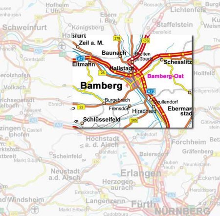
 Bamberg is situated about 60 km (37 miles) north of Nuremberg in northern Bavaria (Franconia). Bamberg is situated about 60 km (37 miles) north of Nuremberg in northern Bavaria (Franconia).
When approaching on the A 73 motorway (Nuremberg-Bamberg), leave at exit "Bamberg Ost". Head towards the city centre on this road for about 3 km (about 2 miles). In Starkenfeldstraße, just before the bridge over the railway, turn right and continue straight on across the first crossroads. You are then in Katharinenstraße. The efms is in the second building on the left. You can find further details on the Street map.
When approaching on the A70 motorway (Schweinfurt-Bayreuth), at the motorway intersection "Bamberg" join the A 73 motorway in the direction of Nuremberg. Leave the A 73 at exit "Bamberg Ost" and continue as above.
When approaching on the A3 motorway (Frankfurt-Nuremberg), at the exit "Pommersfelden/Bamberg" join the B505 feeder road. At junction "Bamberg Süd" join the A 73 in the direction of Bamberg. Leave
at exit "Bamberg Ost" and continue as above.
|